
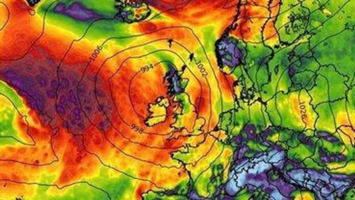
Britain is poised to face strong winds and heavy rainfall in the coming days as winter weather ushers in stormy conditions across the country. Recent weather maps, utilizing MetDesk data from WXCHARTS, indicate that stormy weather is expected on October 19 and 20. By 6pm on Sunday, a band of rain will cover the nation from Cape Wrath in Scotland to Portsmouth in southern England, with only a few coastal areas like Cornwall, Suffolk, and Kent escaping the downpours. Residents in most regions should prepare for rainfall ranging from 0.3mm/hr to 3mm/hr.
The regions likely to be most affected include Gloucestershire, Lancashire, and Devon, with conditions worsening the next day as strong winds intensify, as reported by the Express. The west coast and Midlands of England are anticipated to bear the brunt of the storm, with gusts reaching up to 62km/hr (38mph) in certain areas. Thirteen cities, including Portsmouth, Southampton, Salisbury, Bath, Bristol, Liverpool, Manchester, Salford, Lancaster, Preston, Wolverhampton, Birmingham, and Coventry, are expected to experience the full impact of the inclement weather.
In contrast, the Met Office’s forecast for October 17 to 19 suggests a continuation of cloudy conditions with occasional drizzly showers and some brighter intervals. A shift to more changeable weather is expected from Sunday onward, characterized by the arrival of wind and rain.
Looking ahead to October 20 to 29, the long-range forecast indicates an unsettled pattern with low-pressure systems moving across the UK, bringing showers, longer spells of rain, and intermittent strong winds, interspersed with brief drier and brighter periods. Towards the end of the period, a transition to a slightly cooler and showery northwesterly regime is probable, with temperatures likely to hover near or slightly above average overall.
On another note, parts of the UK are preparing for snow towards the end of the month, with maps showing snowfall in both Scotland and England. Snowy conditions are expected to commence on October 28, with significant snowfall anticipated in the Cairngorms National Park in the Scottish Highlands and light snow showers in parts of North Yorkshire. Meanwhile, other areas like Newcastle, Manchester, and Aberdeen may experience sporadic rain, while most of the country remains dry but cold.
As of the morning of October 29, the snowfall is predicted to ease slightly, with northern Scotland and parts of Newcastle experiencing lighter falls. The majority of the UK is expected to stay dry and chilly, with scattered showers in western Manchester and across the far north. The wintry weather is forecasted to intensify again on October 30, with large parts of Scotland, including Edinburgh, Inverness, and the broader Highlands, likely to face heavy snowfall, while London, Birmingham, Cardiff, and Plymouth are expected to remain dry but cold.