
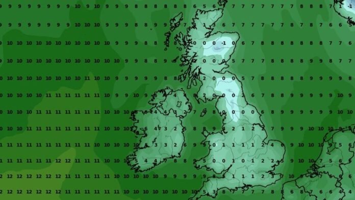
Arctic conditions are poised to impact regions of the UK by the end of this month, as indicated by weather maps, potentially bringing snow and rain. Recent days have seen a drop in temperatures across the country, with some areas experiencing lows nearing 10C and even single figures, notably in Scotland where temperatures reached 8C on Thursday and are forecasted to hit 9C today.
Over the next few days, temperatures are expected to further decrease, potentially falling below zero with wintry showers approaching. Latest weather model projections from the GFS indicate a mix of snow and heavy rain approaching the UK from the Arctic Circle around October 27.
The initial snowfall is anticipated in early morning hours in northern Scotland, with snow likely to accumulate in high-altitude areas, especially the Cairngorms National Park. Data suggests snowfall rates of about 1cm per hour in certain regions as wintry conditions move southward, affecting the North East of England, central Wales, and possibly bringing light snow to Northern Ireland on October 27.
Maps for October 28 show significant snowfall in northern Scotland, with potential flurries of 2cm per hour, while heavy rain is expected in other parts of Scotland, northeastern England, and Northern Ireland. Temperatures are predicted to drop below 0C in some areas on October 27, with the coldest temperatures reaching -1C in Inverness. The mercury is forecasted to range from 0C to 4C, with a slight increase to a maximum of 7C the following day.
According to the Met Office, the upcoming lower temperatures and increased precipitation are part of a “cooler and more showery” pattern expected to arrive later in October. The long-range forecast for October 21 to 30 indicates continued unsettled weather with periods of rain, showers, and potential strong winds, while mentioning brief drier intervals amid the predominantly wet conditions. Temperature variations are likely to be around normal levels, influenced by the movement of low-pressure systems, with a shift to a cooler and showery regime towards the end of the period as high pressure builds over the Atlantic and low pressure centers to the east of the UK.